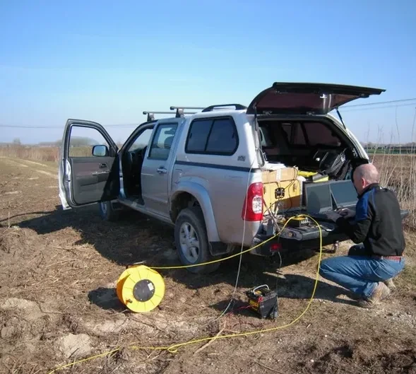
A 14-storey condo excavation off King Street East hit a buried valley we couldn't see with boreholes alone. The overburden jumped from 8 meters to 22 meters in less than 30 meters laterally. That's the kind of surprise that kills budgets. Seismic tomography (refraction/reflection) in Kitchener maps these transitions before shovels go in. The glacial stratigraphy here — tills, outwash sands, and the occasional buried bedrock channel — produces velocity contrasts that a 24-channel seismograph reads clearly. We run both P-wave and S-wave lines. The output is a 2D velocity cross-section showing depth to bedrock, low-velocity zones, and material boundaries. For Kitchener projects near the Grand River valley or over infilled paleochannels, this data changes foundation design. A CPT test can verify soft zones, and MASW adds shear-wave profiles for seismic site class.
Seismic velocity cross-sections reveal what isolated boreholes miss — buried valleys, pinnacled bedrock, and fracture zones that control excavation stability in Kitchener's glacial terrain.
Methodology and scope
Site-specific factors
Kitchener winters freeze the top 1.2 meters of ground from December through March. Frozen surface layers create a high-velocity cap that masks underlying stratigraphy. Running seismic tomography (refraction/reflection) in these conditions requires longer shot records and careful first-break picking to see through the freeze zone. The alternative — waiting for thaw — adds 3 months to the project schedule. Summer brings the opposite problem: dry, loose sand in outwash deposits attenuates signal so fast you lose penetration. We compensate with heavier source energy and tighter geophone spacing. Then there's the cultural noise issue. Active roads like Highway 8 and Victoria Street generate ground vibration that contaminates records. Stacking multiple shots per station and using spectral filtering cleans up the data, but it takes field experience to recognize when ambient noise is winning.
Reference standards
NBCC 2020 – Seismic hazard values for Kitchener, CSA A23.3 – Concrete structures (seismic site class input), ASTM D5777 – Standard guide for seismic refraction, ASTM D7128 – Standard guide for seismic reflection
Associated technical services
Bedrock profiling & rippability
Map depth to Guelph Formation dolostone across the site. Identify pinnacles, troughs, and weathered zones. Estimate rippability from seismic velocities to plan excavation method and equipment.
Seismic site class determination
Measure Vs30 from combined refraction and MASW surveys. Assign NBCC site class (C, D, or E) for structural design in Kitchener's moderate seismicity zone.
Typical parameters
Frequently asked questions
What depth can seismic tomography reach in Kitchener soils?
With a sledgehammer source and 48-channel array, we routinely image to 25–30 meters in dry sand and 40+ meters in saturated till. For deeper targets — like mapping bedrock valleys below 40 meters — we switch to an accelerated weight drop or small explosive source. The practical limit in Kitchener's glacial geology is about 60 meters for refraction work. Reflection surveys can go deeper but require tighter spatial sampling.
Does frozen ground affect the survey?
Yes. Frozen surface soil creates a high-velocity layer that complicates first-break interpretation. We can still acquire data in winter, but it requires longer geophone spreads to capture refracted arrivals from below the freeze zone. Whenever possible, we recommend scheduling seismic tomography between April and November. If winter work is unavoidable, we adjust acquisition parameters and note the frozen-layer velocity in the report.
How much does a seismic tomography survey cost in Kitchener?
A typical refraction/reflection survey in Kitchener ranges from CA$4,020 to CA$6,290, depending on line length, number of spreads, and site access. A single 69-meter line with 24 geophones falls at the lower end. Multiple lines, 48-channel acquisition, or sites requiring brush clearing add cost. Every quote includes data processing, tomographic inversion, and a signed report with interpreted cross-sections.
Can seismic tomography detect voids or caves in the bedrock?
It can flag velocity anomalies consistent with voids, fractures, or solution features in the Guelph Formation dolostone. A void shows as a localized low-velocity zone surrounded by competent rock. However, the method has resolution limits — a cavity smaller than about 1 meter may not produce a detectable anomaly at typical geophone spacing. We often combine seismic tomography with electrical resistivity profiling for higher confidence on void-prone sites.