Last spring we were called out to a site near the Grand River where a contractor had hit an unmapped buried channel during excavation. The fill was a mix of organic silt and old construction debris — the kind of surprise that burns through contingency budgets in a single afternoon. In Kitchener, with its glacial till overlying fractured dolostone of the Guelph Formation, the subsurface can switch from stiff clay to water-bearing sand in less than 20 meters. That is exactly where an electrical resistivity survey becomes the logical next step before you commit to borehole locations. Running a CPT test or drilling program without a prior resistivity profile is like doing a surgical incision without an ultrasound — you risk missing the most critical anomaly. We use VES arrays to image bulk resistivity contrasts, helping you target invasive investigations where they actually matter, whether you are planning a mid-rise on King Street or a stormwater pond in the southwest expansion area.
In Kitchener's glacial terrain, resistivity is the only non-invasive tool that reliably separates a clay aquitard from a water-bearing sand within the same depth window.
Methodology and scope
Site-specific factors
Kitchener's growth from a small Mennonite settlement in the early 1800s to the twin-city core of Waterloo Region has left a legacy of buried infrastructure, old creek alignments, and undocumented fill across downtown and the Innovation District. You cannot rely on historical maps alone — we have seen sites where Schneider Creek was culverted and diverted so many times that the original channel shows up only as a low-resistivity smear on a VES profile. Skipping a resistivity survey in these areas means accepting the risk of encountering buried concrete, old storage tanks, or saturated organics that can delay your project by weeks. On the geotechnical side, resistivity data also feeds into corrosion risk assessments for buried steel and concrete durability evaluations, both required under CSA A23.3 for structures with a 75-year design life. When you factor in the cost of a single change order versus the price of a resistivity survey, the math is not complicated.
Reference standards
CSA A23.3 — Design of Concrete Structures (durability and exposure classes), Ontario Building Code (OBC) — Part 4 structural design references, ASTM D6431 — Standard Guide for Using the Direct Current Resistivity Method for Subsurface Site Characterization, Canadian Dam Association — guidelines on geophysical investigations for dam safety (applicable to GRCA projects)
Associated technical services
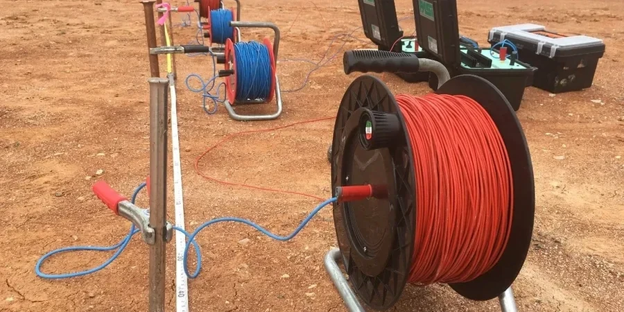
1D Vertical Electrical Sounding (VES)
Single-point sounding using Schlumberger array to map resistivity variation with depth. Ideal for borehole planning, water table profiling, and assessing depth to bedrock across smaller building footprints. We provide a 1D inversion with layer thicknesses and interpreted lithology tied to regional Quaternary geology maps.
2D Electrical Resistivity Tomography (ERT)
Multi-electrode profiling along a transect, producing a continuous cross-section of resistivity. Recommended for linear infrastructure, slope stability investigations along the Grand River valley, and mapping lateral changes in overburden thickness. Data inverted with topographic correction and presented as a colour-contour section.
Typical parameters
Frequently asked questions
How much does an electrical resistivity survey cost in Kitchener?
For a typical 1D VES sounding in the Kitchener area, budget between CA$840 and CA$1,410 per location, depending on target depth and site access. A 2D ERT line usually runs higher because of the larger electrode array and longer field time. We provide a fixed-price quote after reviewing your site plan and project objectives — no hidden charges for mobilisation within Waterloo Region.
Can resistivity tell the difference between clay and water?
In Kitchener's glacial deposits, it usually can — but context matters. Saturated clay till typically reads below 50 Ω·m, while clean, water-bearing sand and gravel read above 100 Ω·m. The tricky scenario is a silt-rich sand with high dissolved solids in the groundwater, which can mimic a clay signature. That is why we always calibrate resistivity profiles against at least one borehole or CPT log when available.
How deep can you see with a VES survey?
With a Schlumberger array, the rule of thumb is roughly one-third to one-half the maximum electrode spacing. If we expand AB/2 to 150 m, we can image resistivity contrasts down to about 50–75 m below grade. That covers most Kitchener projects, but if you need deeper investigation — for a deep well or quarry assessment — we can discuss alternative arrays or complementary methods.
Do you need special permits to run a resistivity line in Kitchener?
For private property, no permit is required. If your survey extends into a City of Kitchener right-of-way or a GRCA-regulated area near the Grand River, we handle the encroachment permit or conservation authority notification as part of our scope. We have done enough work in the region to know the process and avoid delays.